Tuesday, October 31, 2017

Beckey Has Passed On

Via The Mountaineers Fred Beckey has left us (remembering-mountaineer-fred-beckey). I never met Fred Beckey personally, and I never categorized myself as a climber. But regardless I felt I had met Beckey. During another era I worked in the North Cascades and the three geologists I worked with had dogged eared copies of Becky's guide. At that time I viewed him as a guide to personal terror. He had ventured into extremely difficult terrain prior to our geology ventures and his guide books provided the descriptions on how to get to places that tested my nerves and fortitude.

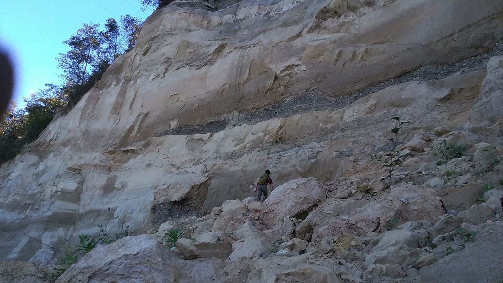
A few years later I utilized his guide books to navigate into areas not for peak ascents but to explore the geology of a specific area in the North Cascades Range. I did take some pride in navigating an ascent approach within my own field area that even Becky described as an unpleasant route that he backed out of but still provided as an approach route option. The route was not some great climbing route, but was an absolutely miserable 5,000-foot ascent through thick"dog hair" Douglas fir to the base of a glacier where the alpine ascents began. My first attempt of the route ended in miserable retreat. The second time was completed successfully as a solo venture that include my longest stint of no other human interactions after reaching the edge of a the high glacial area below a string jagged Becky first ascent peaks.

While I have looked up to many of his first ascent peaks and routes, I was more impressed with the access routes he pioneered to even get near some of the North Cascade peaks. The challenge of the North Cascade climbing he pioneered was a mix of technical combined with very physically demanding approach routes into and through the deep valleys within the range.

Getting to the many of the North Cascades peaks Becky climbed takes passion and a physical fortitude few people possess. But pioneering these routes also took judgement - very good judgement. That judgment explains more than anything else how Becky survived so many of his adventures and led such a long life. He had the ability to read a landscape without guidance and I am struck by how many of his ventures took place through times when he was young and may not have known better and when he was experienced enough that he could have been fooled by arrogance.       

Sunday, October 29, 2017

GSA Talks Ice Sheet Grounding-Zone Wedges

The first half of last week, Sunday through Wednesday was taken up at the Geological Society of America meeting in Seattle. Hundreds of talks and presentations to choose from over a three day period. Deciding on which talks to attend was at times difficult. 

One of the early talks I went to was titled Sedimentary Processes at Ice Sheet Grounding-Zone Wedges: Examples From Antarctica and Washington State (U.S.A) (Demet and others, 2017). This talk had some practical applications to my own work on landslides.The talk was a brief version of Demet (2016) thesis work on some of the shoreline bluffs of Whidbey Island.

When the Puget ice lobe retreated the sea invaded Puget Sound and for a time the glacial front consisted of a front of grounded ice (ice in contact with the ground) and a sheet of floating ice. Demet and others (2017) recognized several locations where the grounding line may have been present on Whidbey Island as the ice retreat paused and suggests that the grounding line area became an area where there were some minor readvances of the ice sheet.


A few weeks ago I observed some highly distorted and complex glacial sediments along a steep shoreline bluff along the Strait of Juan de Fuca. Seeing deformed glacial units is not unusual, but the degree of deformation and the cross cutting relationships were perplexing. The area was a mix of glacial outwash, glacial tills and glacial marine drift that was not following the pattern of what is the more typical sequence of units. Understanding the units and just what units I was looking at was a critical component of assessing the potential bluff failure mechanisms. In particular, at this site the presence of poorly compacted glacial marine drift was of interest because it appears to be the cause of some of the larger scale failures that are present on portions of this particular bluff. 

The pattern of units appears to be consistent with the observations made by Demet and others (2017). Perhaps a more diligent comparison would be in order.

Saturday, October 21, 2017

Election Forum - Whatcom County Jail Tax

Jails are very much a part of the Washington landscape (had to get that in). Every county in the state has one as do many of the cities. The county jail is the leading edge of the United States criminal justice system. The jail is a big part of every County budget. Criminal justice and criminal justice spending is complex.

So for Whatcom-centric folks that are trying to decide how to vote the jail tax you can get a couple of perspectives here, but this conversation is at some level very much part of every community (Jail Woes). I am the Vote No Jail Tax person in this video. For a short cut version I have a few major points below.


Cost of the jail will be $250,000 per bed compared to Skagit County at $120,000 per bed. This puts the proposed Whatcom jail as one if not the most expensive jail per bed in the United States.

Tax proponents have stated that some of the tax money will be directed to incarceration reduction programs. There is no guarantee that will take place and the amount suggested is initially $500,000 per year. The amount will go to the jail construction will be $6,759,208 per year assuming the bonds to pay this amount over 30 years can be had at 4.5% and the jail come in on budget.

The existing jails were evaluated by a engineering firm and were found to be "structurally sound and in fair to good condition". They estimated that both jails could be upgraded and maintained at a cost of $32.4 million over a period of 20 years. The cost of the proposed jail will be $202 million over 30 years, and the $202 million assumes no future expansion.

The same engineering firm that reviewed the jail conditions asked the county if a portion of the existing low security jail be improved and hardened for medium security. The 'County officials' stated that the would have to have new public outreach and this was a nonstarter. The fact is the county never evaluated this option in a public manner nor any other options.

When the County did an EIS on the jail they only evaluated options 1) build the proposed jail or 2) don't build a new jail. Given that this project is by far the largest capitol project in the county with broad community impacts that will last generations and evaluating only 2 options is a poor way to make such a large decision. I testified to that during the EIS process.       


Tuesday, October 17, 2017

Yakima Canyon and Bighorn Sheep

There are two road routes between Ellensburg and Selah. One is Interstate 82 is the high road passing over Manastah Ridge, Umtanum Ridge the shoulder of Selah Butte. The other is route is very slightly shorter (less than a mile) but slower. That route is the low route that follows the incised meander bends of the Yakima River as it winds through the ridges. 


The lower slopes have more water and shade and hence the canyon is a nice mix of scrub steppe with patches of ponderosa pine ecosystems as well as riparian areas along the river. Driving the canyon (or floating) one has a sense of the meanders, but an aerial view shows that some of the bends in the river are very tight.


Much of the east side of the canyon (the road side) is managed by the BLM. The west side is mostly Washington State Fish and Wildlife managed land with some Department of Natural Resources and BLM. The Nature Conservancy also has a presence. The canyon is a popular recreational area for rafting, tubing, fishing and hunting.

Along one of these meander bends I slowed to take in the views of scree slopes just above the road (the slopes in question can be seen above). My geology slow down allowed me to spot two bighorn sheep, a ewe and her now large lamb.


It was good to see them. Bighorn sheep throughout the west are subject to pneumonia outbreaks that are thought to have originated from domestic goats and sheep, but not in a very straight forward manner. The outbreaks and how the bighorns are impacted is not a simple problem nor are the responses (http://bighornhealth.org/publications/). The two Yakima Canyon herds suffered large losses in 2010 (State, federal wildlife officials to selectively remove sick Yakima River canyon bighorn sheep); hence, it was good to see a ewe and her maturing lamb.  

Saturday, October 14, 2017

Santa Rosa Fire Notes - My Old Town

I have a more than passing interest in the wildfire that burned into Santa Rosa. I lived there and taught school there for three years. The fire that burned into the north portion of the city torched hundreds of homes within a very urban setting within 3,000 feet of where I lived. A very humbling thing to contemplate that homes in an urban neighborhood were at risk from a wildland wildfire. Wind and heat matter.

This map https://api.mapbox.com/styles/v1/robinkraft/ provides an interactive viewing of the burned area with infrared imagery.

Screen shot of the burnt neighborhood
Red areas are live vegetation

I wanted to get a sense of some of the areas that burned associated with this fire. The fire start was from north of the map program (there are other burned areas covered as well shown on the map).

The fire reached the northeast part of the city in Rincon Valley. The fire had burned through very steep rugged hills that are a mix of grass, thick brush, oaks and drought tolerant pines. A very fire prone ecology. Stopping a fire in hot windy weather in that terrain would have been impossible. The Rincon Valley is a mix of small farms, semi rural/suburban area on the north and urban on the south.

Infrared image of burn area along the north edge of Santa Rosa in the Rincon Valley.
Arrow shows the approximate direction the fire burned.

Approximately the same area via Google Earth (July 2016)

Much of the Rincon Valley near the city edge is grass land. The area gets over 30 inches of rain a year so the grass grows very thick and tall through the winter and early Spring. Typically by June things are already fairly dry. The  The grass readily burns and burns fast. Based on infrared image the fire did not kill the trees. A grass fire through a stand of trees often does not damage the trees. That said, this fire moved very fast and burned into the edge of the city shown above destroying dozens of homes.

Destroyed homes south of grass field 

I did a street view tour of  the ground in the Rincon Valley along a former running route that I used to run on Wallace Drive. The street view images are from June 2016.

View looking east towards the rugged hills on the east side of Rincon Valley  


This field was plowed - a very good way to reduce wild fire in this setting

However. across the street, to the west was an unplowed and ungrazed field.
Note the trees become thicker and dense up the slope in the distance.

Infrared of street views shown above

It appears that the perimeter of the field shown above is routinely plowed in late Spring. Some homes were destroyed in this area as the fire burned through, but may of the trees survived and still have their leaves. 

To the west of Rincon Valley the landscape changes as does the vegetation and then again the densiy of homes.

A forest and brush covered ridge bounds the west side of Ricon Valley with much denser housing on the west side of the ridge

The fast moving grass and brush fire with high wind and heat pushing it must have burned up the ridge into that dry forest and brush and exploded into the suburban homes nestled into the forest and brush landscape.
Street view of the ridge area
Chaparral and pines and homes 

Nearly every home in this suburban neighborhood was burned. I tried looking at roof types and building materials via street view. Wood siding and asphalt roofs were allowed in this suburban neighborhood. That said, there were tile roof and stucco homes that burned. One odd home that did not burn in the middle of the conflagration had an asphalt roof and wood siding.

Why this house? Arrow points to a house that did not burn

The burning of the Coffey Park area on the northwest part of the city is the truly humbling aspect of this fire. The neighborhood was flanked by urban commercial and light industrial buildings as well as a 4-lane divided highway. The fire jumped the highway and hundreds of homes burned out of control well outside the much discussed wildland/urban interface.


A lesson every fire person knows - a fire with heat and wind will find any bit of fuel to burn.


Friday, October 13, 2017

Jail Tax Forum Prep and the Jail Work Crew

Whatcom County Jail Work Crew at Lake Bridge Project
Mount Baker-Snoqualmie National Forest 

I am doing some crash research related to a forum I am speaking at tomorrow. The forum is on a proposed sales tax in Whatcom County for building a new jail. I am speaking against the jail tax.

This is a complicated subject. I do have some background on the subject having had to make lots of budget decisions during my 8-year stint as a county council member. How I got to NO on the jail tax is not the same as how others have and that complicates things further. The end of my planned opening statement tries to reflect that: "I cannot articulate everyone's nuanced views and concerns about this jail tax, but ask that you please join me and vote NO on the new jail tax. I will try to the best of my ability to answer your questions today."

In digging through the Incarceration Prevention and Reduction Task Force files I came across the above picture. The Whatcom County Sheriff Office has been running this program since the Federal Secure Rural Schools and Community Self-Determination Act (https://www.fs.usda.gov/pts/) passed in the early 2000s. They have been doing work on National Forests trails ever since. Good to see some positive stuff in an otherwise downer subject. 

Friday, October 6, 2017

Learning at a New Landslide

Our purpose was to assess a steep shoreline bluff slope along the Strait of Juan de Fuca. Getting to the base of the slope meant taking a mile walk along the shore from an access point. This particular shoreline bluff is and has been a challenge to assess. The overall driver of landslides is erosion at the base of the slope. However, the shore bluff failures along this reach vary a lot due to the variability of the geologic units along the shoreline bluff. This shore reach is sort of a landslide lab. For my work, visiting and exploring a new landslide is a great way to learn and sometimes be humbled. 

On the way to the site for our work we encountered a fairly large new slide, and hence, an opportunity to learn.

 
I had walked this shore last October, and this slide post dates that visit.


We ended up spending a much longer time on this venture than originally planned. One part was to to try to figure out the mechanics and scale of the failure. What units failed? What was the mode of the failure? We spent time making observations, coming up with theories and explanations. The slide also provided an opportunity to observe up close some the geologic units on the bluff. While looking at this slide was not directly associated with the site we were to visit later, it helped inform our assessment and in the future will help inform our interpretations of other bluffs with similar conditions.

Yesterday I gave a short talk to a realtor group as part of a panel with the goal of helping realtors and their clients doing their due diligence for raw land. I noted that part of my work is driven by the desire for view property and that landslides do provide great views.