Wednesday, July 26, 2017

100 Years Plus of Fossil Fuel in Whatcom County Policy Shifts

Over time values and what society cares about  shifts.

Over time society values and what people care about shifts. The Whatcom County Council in a 6-1 vote reflected some of that change in thinking. The Council voted on some policy changes to the Cherry Point area of the county:  http://www.whatcomcounty.us/DocumentCenter/View/28301

Cherry Point is designated stand-alone urban growth area designated for heavy industrial land use. The designation as urban is a bit unique in that it is not associated with a city. The area is used by two oil refineries and an aluminum smelter. All three are served by deep-water piers. The deep water access and out of city location made this area attractive as heavy industrial site.

The council action was at least in part a reaction to the permit process that was triggered by the application for the construction of a large coal export terminal. It was also a reaction to larger changes taking place at the national level regarding crude oil and a concern that the site could become a crude oil or natural gas export facility.

The policy shifts are not very big, but they do recognize some changes and concerns that were not recognized in the past such as the potential of exporting crude oil or other unrefined fossil fuel products, the impact of rail shipping to the terminals, and the recognition of treaty rights regarding the usual and accustomed fishing and hunting areas. The last item is a big deal and was to a significant degree ignored by the recent coal terminal proponent.

The hearing was very long lasting from a bit after 7:00 to 12:00. The range of views was interesting to listen to, but hearings this long are a test of endurance.

The Council takes in 5 hours of testimony - 3 minutes max per person

Contrary to some views expressed, this has policy shift had been a long process that started nearly a year ago and had already gone through a lengthily public process with hearings and changes to the original proposal.

The most forceful objections were from BP oil. They do not want restrictive policies regarding crude export or new pier construction. They took a number of approaches to their objections, including some mischaracterization of policy changes. The main objection is that by removing the possible ability to use the site as a crude oil export facility, the operation
Anti change rally before meeting

A strategy of the anti change group was to hold a rally. There were an equal number of pro change folks that held a smaller rally and filled the council chambers before the meeting.

Pro policy change or not, society values do shift. Bellingham was once a coal town.

Mine entrance and infrastructure in the northwest part of Bellingham
This mine closed in 1954


Blue Canyon Mine loading facility in the 1890s prior to the rail line to the mine

Coal terminal in Bellingham Bay


Sunday, July 23, 2017

Strait of Juan de Fuca Mole

An article discussing Dunkirk's Mole reminded me of the mole on the shore of the Strait of Juan de Fuca.

Oblique view of mole on the Strait of Juan de Fuca (Ecology, 2006)

The mole along the Strait was used for loading clay onto barges from a clay mine up slope from the mole. The clay is from marine sediments of the Pyhst Formation. The clay was used as an additive to cement mixes.

The mine was a rather short lived operation. The Pyhst Formation is a rather notoriously unstable formation (clay!), and numerous very large landslides are associated with the marine clays. The mining slopes destabilized the slopes and activated a very large deep-seated landslide. The bare ground in the image above was part of the mine wall that failed, but the area of the slide is actually much larger and extends well into the uplands towards the top of the above photograph.

There has been some discussion of removing the unused mole as it is a protrusion that interferes with beach processes. I am not up on the status of that scheme. But the mole and the mine scheme are good examples of an approach to land use and shoreline use with long term consequences to the public in exchange for short term gain.    

Friday, July 21, 2017

Sceloporus occidentalis, western fence lizard at Port Discovery

A few years ago I was walking the beach at Port Discovery and noted a lizard on the driftwood along the upper beach. Seeing lizards in the field in many places I have worked would not be much to note. But in western Washington seeing lizards is not common. Our cool wet weather limits good lizard habitat to a limited area of drier locations. 

On a recent trip to Port Discovery I was traversing a steep slope well above the bay and got a very brief glimpse of one lizard and then a second lizard chose to stay still. 

Sceloporus occidentalis, western fence lizard (thanks to Lori and Roger for the ID)

The lizards were located well above the beach, 350 feet above. The slope is southwest facing and in the rain shadow of the Olympics. There is evidence that these slopes have burned on a periodic basis and the slopes are very dry with a mix of grass land and trees and brush. Pretty good habitat.  

View of slope area

The underlying geology of the slope was sandy and gravelly glacial till on the top of the slope with sand and gravel glacial advance outwash below. Older glacial and non glacial units are present further down the slope.  

View of habitat from above just above some glacial till exposures

Vie of the Port Discovery bay from the open slope
Species observations from

This lizard species occupies the east slopes of the Cascades, the Columbia River Gorge, the Blue Mountains and the prairie areas of the Puget lowland. The north Puget lowland areas are a bit of an outlier, but match reasonably well with the other habitats as areas that dry out for longer periods due to a combination of climate, slope aspect and soils.  

Friday, July 7, 2017

Bellingham Marine Heritage Park and Holly Street Landfill Notes

I took a walk down Whatcom Creek to the upper Whatcom Creek estuary in Bellingham. Its a nice walk through the city urban center along the creek and the waterfall at the head of the estuary.


The passage along the creek and falls is a great perc to have in Bellingham.

I walk this trail fairly often as it leads from my office to the main post office, or, if I continue, through a park to one of my favorite watering (beer) holes. The park is Maritime Heritage Park. This park is where Bellingham began as a town due to the presence of the waterfall and its ability to power mill equipment. I have noted the changes that this bit of landscape has gone through before (shifting-landscapes-and-shifting-values), but that previous post left off the post saw mill period.

Post saw mill time, the estuary embayment was, like many waterfront areas, during that 1900s era viewed as an opportunity to create more land. From at least the 1930 through the early 1950s much of the estuary was filled. Much of the fill consisted of municipal garbage.

Post filling the site with garbage some commercial development took place and part of the estuary also housed the municipal sewer plant. Some of the buildings were not well founded and as the garbage settled, the structures began to sag. The Shrimp Shack provided an excellent geotechnical example of differential settlement that upped the geotchnical knowledge base of ordinary citizens.

By the late 1900s, the community values had shifted again and the City of Bellingham saw an opportunity to turn the area into a park. The City partnered with Washington State Department of Ecology and to remediate the legacy of what is now called the Holly Street Landfill.

Part of the remediation was pulling the garbage back away from the creek on the north bank and slightly widening the remaining estuary.

Estuary in 2004 from the DESIGN ANALYSIS REPORT (Anchor Environmental and Aspect Consulting, 2004) 

Estuary 2017 - note tidal bench area at base of the slope relative to no bench in the 2014 image


The southeast side of the estuary landfill is a well used park and includes a native plant restoration area with signage for many of the plants.


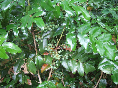
Tall Oregon grape has a relative:


Within the restoration plantings I noted that the western red cedars were not doing very well.


A possible explanation is the last few summers have had very long dry spells. Seabacher (2007) suggests that changing climate with longer summer dry periods could reduce western red cedar range. Given the current distribution of the tree, a few hot dry summers along with the obvious water competition of other trees could preclude western red cedars at this site.


The upper estuary at the base of falls was in use during my walk:

Canadian geese and great blue heron
The cement wall was part of the former sewage treatment plant once located at the estuary

A bit of the former garbage dump has been eroded along the southeast bank of the creek exposing old glass and metal.


Monday, July 3, 2017

Those at Highest Risk on July 4th

On Turkey Day I have a bit of a traditional post on safe travels via Lisa Hannigan (a-turkey-day-blog-tradition-safe-travels).

For July 4th Brian Resnick point out an obvious vulnerable population to fireworks (fireworks-injuries-hospitalizations) and includes a chart showing just who is at risk:


Try to keep those teenage boys and young men safe. As a former member of that group, it is not easy.

Saturday, July 1, 2017

Nanaimo Group Extension Formation on Orcas Island

I got a little glimpse of one small portion of the Late Cretaceous Nanaimo Group on a recent visit to Orcas Island. 

The Nanaimo Group is a group of sedimentary formations exposed along the west side of Vancouver Island and in the islands between the BC mainland and Vancouver Island. Geologic maps indicate there is a bit of Nanaimo Group underling the northernmost portions of the San Juan Islands and along the north part of Orcas Island.  

This group of rocks have been receiving some recent attention by those trying to piece together the western North American margin story. Brown (2012) has interpreted a few scattered outcrops of slightly metamorphosed conglomerates (northwest corner of Blakely and Upright head at the ferry landing on Lopez) as being older Nanaimo Group, suggesting the earliest Nanaimo sediments were incorporated into the final assemblage of the San Juan thrust stack and thus adding a time constraint on when the tectonic terranes that make up the San Juans were stacked up. Mathews and others (2017) and Mahoney, (2016) have attempted to work out some of the source material via dating of detrital zircons in the Nanaimo sediments which have narrowed but not fully resolved the potential sources of some of the sediment. Difficult and complex tectonics that requires piecing a lot of scattered and detailed information together to develop an interpretation. 

My very limited look at the Nanaimo was a chance to see just one tiny bit of the story theses rocks may hold. The part of the Nanaimo Group I was looking at is mapped as the Extension Formation dated at approximately 84 million years. My first view was on a bedrock bald with very thin soils and vegetation.   


As my field work typically involves slopes, I came across a cliff of the bedrock within the forest on my traverse. The slope and cliff were north facing and within the forest so the light was dim despite it being a sunny day.


The Extension Formation is primarily a conglomerate. At this site the conglomerate is primarily cobbles and boulders. Due to the light and steepness of the slope, I ended up with some blurry images, but did get few illustrative shots of the various cobbles and clasts.

Granitic boulder

Andesite boulder


metamorphosed sandstone?

Granitic pebbles

Vein quartz clast?

The short story is that this exposure of the Extension Formation is a clast supported pebble to cobble conglomerate to very coarse sandstone that was deposited in a high energy environment. The size of the granitic cobbles to boulders suggest fairly close proximal to a granitic source material. The Extension Formation has been interpreted to include high-energy deposition in deeper marine submarine canyon and fan facies in northern areas of Nanaimo Group, and shallow marine to coastal to braided fluvial depositional environments in the Nanaimo area where coal is present. This rather wide range of depositional environments seems a bit odd as a single formation, but my grasp of the Nanaimo Formations is limited.