Thursday, June 30, 2016

Eurasian Collared-Doves: Trump Won't Stop These Immigrants

A new species of bird has swept into Washington State. A flock of Eurasian collared-dove escaped in the Bahamas in 1974 and spread to Florida. From there the species completed a rapid expansion across much of the United States and is starting to become a common species in Washington State. A very remarkable expansion over a short time period across a wide range of habitat and ecosystems. 
 
Not the best camera for bird pictures, but I did get a few distant shots of this skittish bird. Much easier to hear there call. 


Tuesday, June 28, 2016

Brexit II and Volcanoes

With a fair bit of field work travel including camping I have had a fair bit of radio Brexit exposure from NPR, CBC and BBC.  

Brexit II (Iceland 2 England 1) is perhaps less consequential (at least for some).

"The worst defeat in our history. England beaten by a country with more volcanoes than professional footballers." - Gary Linker

Saturday, June 25, 2016

The Deer Invasion

Lots of diverse field work ventures over the past week. Deep geo probe drilling, urban settings and work in wet cloud enshrouded forest. Camping in the rain with a good book and hearing the vibration of knight hawk wings as they made a dent in the local insect population.

I also got a good look at the continuing invasion of deer into the urban landscape. The morning I left Bellingham, three adult deer passed down our urban street of 50' x 100' lots located between the freeway and downtown. At a construction site in another town, a fawn was napping on the warm soil above the concrete forms.

 
In the evening, two more fawns made a dash across the street without looking both ways before crossing.


The presence of deer in urban areas is not due to human encroachment on the deer habitat, but deer encroachment on human habitat. Urban settings provide significant advantage to deer. Typically these are no hunting zones, the initial reaction by people may be more favorable, and predators, at least for now, are much less likely to be encountered.

Thus far my anecdotal take is the Port Townsend might have the largest invasion of deer in the state. It is rare that I do not see deer when I visit PT. Their boldness in lack of concern about proximity to humans is impressive.    

Sunday, June 19, 2016

Spectacular Spheroidal Weathering above Babcock Bench

Ken gave me a bit of a tour to a few ice age flood and flood basalt sites. One site was the best spheroidal weathering I have seen - at least from an aesthetic standpoint.
 
Top of weathered basalt columns
 
Top of weathered basalt columns above the ice age flood scoured Babcock Bench

Columns and spheroidal weathering

A fully detached column top
Babcock Bench below and Columbia River in the distance

Saturday, June 18, 2016

Chuckanut Weather

The Chuckanut Range is a localized term for the range of mountains between the Samish/Skagit Flats and Bellingham. The range is also described as the location where the North Cascades reach the sea due to the continuous mountainous terrain to the waters edge at this location.
 
The sharp 2,000-foot plus initial rise creates a bit of localized weather as moist air rises up the slopes. The result is a rapid increase in precipitation in the vicinity of the range. 
 
View from Bow of Chuckanuts with cloud cap
 
Rainbow above Chuckanuts at sunset
Foreground is a recent fish and wildlife project on Samish Flats

Clouds on the Chuckanuts

Encountered a bit of snow on the pass (Stevens) when heading to central Washington. The big cool down made field ventures on the east side of the mountains very comfortable.


Thursday, June 16, 2016

Pelicans and Cormorants Fishing at Horn Rapids

Fishing within 400 feet of Horn Rapids Dam is prohibited; however, First Nations have a treaty right to fish at the rapids as they have for millennia. Another fishing group are American white pelicans and cormorants. 


Both these species have been making a comeback in eastern Washington. Dennis Paulson provides a nice summary on the American white pelican HERE.

Horn Rapids Dam is a irrigation diversion structure on the lower Yakima River. Water is diverted into canals on both sides of the river at the top of the rapids. The spill area makes for good fishing and the rocks downstream provide good perch areas out in the water.


Monday, June 13, 2016

Herons on My Mind

I have been trying to figure out our heron neighbors. They do a lot of flat out screaming. I suppose I would too if a creature with sharp talons approached one of my offspring (Norman, Breault and Moul, 1989).

Walking along Samish Road on Samish Island I heard the screaming of the local heron rookery and observed a bald eagle with what I assume to be a young heron in its talons. The bald eagles routinely pass over the nesting trees of the herons. Jones, Butler and Ydenberg (2013) note that great blue herons may be using proximity to bald eagle nests as a means of protection. Despite the predation by eagles, the eagles are also territorial and keep other eagles away as well as other potential predators away.

As both species populations have recovered from the DDT era they are developing a complex interaction. The same goes with interactions with people. As populations recover interactions will only increase.

In the past a heron that tolerated human approach could well end up as feathers in a hat. But today a tolerant heron may get more to eat (wildfidalgo.blogspot.heron-luncheonette).

Sunday, June 12, 2016

Wentachee Pick of the Week

I will be in Wenatchee on Tuesday: www.wenatcheeworld.com/news/check-it-out-our-arts-and-entertainment-picks-of-the-week/.  Nice promotion work by Ice Age Floods Institute Wenatchee Valley Erratics Chapter: http://iafi.org/local-chapters/wenatchee-valley-erratics-chapter/

The talk will be on what was happening in Western Washington during the ice age floods in eastern Washington. I should note that the far southwest Washington was impacted by the ice age floods as well. And there were some major surges of water elsewhere in western Washington. I'll pay a little bit of homage to J Harlen Bretz as he compiled some of our early understanding of western Washington lowland glacial history.

Approximate maximum continental ice extent

Thursday, June 9, 2016

Missed Photograph of Swimming Bald Eagle

Last week I spotted a bald eagle swimming. The bird appeared to be doing the butterfly stroke lifting it wings out the water and then plunging them back in with a definite reaching forward to propel itself. 

It took me a while to realize what I was actually seeing. The bird passed around a bedrock point and out of view before I could take a picture.

As I continued along the shore I flushed the eagle. The bird managed to lift off the ground with a large fish and despite the troubled take off managed to get into a tree perch where I would not be able to steal his catch.


Tuesday, June 7, 2016

Oil and Fuel Ship Parking at Samish Bay

Fuel tanker in Samish Bay with Chuckanut Range behind

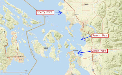
Samish Bay is used as a fuel ship parking area. The bay is fairly protected from long fetch wind driven ways. Further protection can be gained by slightly adjusting position within the bay during high wind events. The bay provides good access to the northwest Washington oil refineries at March Point and Cherry Point. The water is too deep and too open nearer to Cherry Point. The waters around March Point have limited space with narrow shipping lanes and very shallow water to the east in Padilla Bay. Hence, Samish Bay and the adjoining bay to the north, Bellingham Bay, has appropriate depth and proximity to be a good anchorage for oil and fuel ships.


A variety of oil and fuel ships and barges use the space when waiting to either load or off load their products. The big tanker ships will pull into the bay and wait for off loading when dock space at the refineries is taken or if some time is needed at the refinery for having the right blend of crude oils in their mixing tanks. 

Oil Tanker on Samish Bay
North tip of Samish Island on the left and Lummi Island in the distance

Waiting ship on Samish Bay
BC Coast Range in the far distance

The ships are fully crewed while they wait and there are a number of attendant tugs that serve the ships as well as the barges that anchor in the bay. Non fuel bulk ships and even on occasion container ships use the bay on occasion, but are more typically anchored to the north within the adjoining Bellingham Bay.

The fuel and oil ships and barges and their crews are regulated and monitored by a combination of international ship safety conventions, the Coast Guard, the State of Washington Department of Ecology and the Washington State Board of Pilotage Commissioners. The additional regulations in place by Washington State is an added expense that has been deemed well worth the cost by the Washington Legislature as the cost of a mishap would be very dramatic for seafood industries, recreational users and property owners in the Salish Sea.   

Sunday, June 5, 2016

The Bern in Washington State

The LA Times has an article and interactive map on Bernie Sanders donations.     http://www.latimes.com/projects/la-na-pol-sanders-donors/. Sanders is not going to prevail in his campaign, but whether you feel the Bern or not, the donation support he has received is impressive.

The map interactive feature of being able to click a zip code allows a quick assessment of how much money came from each zip code. The color coding is based on a per capita of total money in the zip code divided by the population. Hence, the dark patch in central Washington is based on a few donations within in a very small population zip code that covers a large rural area.


I checked out a few areas on the LA Times map. My own zip code is dark green. This is not a surprise as the zip code area is very heavy Democrat, tends to be very lefty even within the Democrat party and simply my own interactions with folks in my hood. The zip code donated $185,481 to Sanders. This donation rate far out paces local elections! My mother's zip code has a slightly larger population and sent $18,939 Sanders way and is colored light green. This is consistent with Democrats in that area being a much smaller percentage of the population.

However one may interpret the map and the numbers, the Democrat Party leadership is likely to want to somehow keep at least some of that deeply felt support. And if that enthusiasm could be directed to state and local elections, maybe the Bern folks would get their revolution after all. 

Friday, June 3, 2016

AGU Blogger Callan Bentley Notes fron Eastern Washington

Callan Bentley is one of several bloggers at the AGU site. He recently visited eastern Washington on a field trip before the GSA Rocky Mountain metting on Moscow, Idaho. I have enjoyed his take on eastern Washington geology - it really is an amazing place and sometimes it helps to have an outsider remind us about how amazing our landscape is.

Callan makes use of a GigaPan camera so you can enjoy some virtual touring of road cuts.

Callan's Washington posts:

blogs.agu.org/mountainbeltway/flood-deposits-glacial-lake-missoula-outburst-floods

blogs.agu.org/mountainbeltway/varves-along-hawk-creek-washington

blogs.agu.org/mountainbeltway/2016/05/31/baked-horizon-columbia-river-flood-basalts

blogs.agu.org/mountainbeltway/pillow-basalt-exposures-columbia-river-basalts

blogs.agu.org/mountainbeltway/spheroidal-weathering-columbia-river-basalt


Wednesday, June 1, 2016

Finally California Poppy Success


I have been trying for several years to get California poppies established on the rockery wall between our yard and the alley. Its not a rare plant by any means, but this year I finally had success with seed stuffed in the wall last year. The seeds came from poppies growing out of cracked pavement in Mukilteo.