Friday, January 31, 2014

Valdez Alaska: Massive Avalanche and ice dam in Keystone Canyon

Besides being rather impressive in the near term, the lake formed by this avalanche does cause me to wonder a bit about the deposition behind the ice dam and how some future geologist might interpret a broad silt deposit across the valley floor. Article: highway-to-valdez-to-be-closed.


Big mountains and lots of heavy snow. Valdez is a remarkable location of huge mountains and massive snow. This winter has been mild Valdez setting up massive avalanches.

Valdez is also the terminal for the Alaska pipeline that brings oil to tankers and ultimately to northwest Washington refineries. Apparently geologists and engineers back in the 1970s felt it best to bury the pipeline through this section of the route.  I'll add that I worked on the pipeline project manufacturing insulation jackets for the pipe in Pasco, Washington. The insulation was loaded onto barges that headed down the Columbia River and then up to Valdez. The work did pay for most of my first two years of college; but the 90 plus hour work weeks did take a bit off my early season cross county races.

Thursday, January 30, 2014

Undammed Rivers Updates

Ian has an update on the Elwha and the most recent lowering of the Glines Canyon dam http://coastnerd.blogspot.com/2014/01/glines-canyon-dam-now-invisible.html.

Steve Stampfli has been documenting the post dam removal on the White Salmon and documents a recent cliff face collapse that was formerly submerged http://whitesalmontimelapse.wordpress.com/2014/01/29/landslide/#respond.

I suspect the cliff face may have pealed off due to freeze thaw action which would have been on pause when the cliff was submerged. Of course the driver is also slow undercutting by the river that formed the cliff in the first place.
 

Tuesday, January 28, 2014

Maury Beach

My associates over at Coastal Geologic Services have suggested the name Maury Beach Park for the new park on Bellingham Bay in Bellingham. The City of Bellingham is seeking input on name suggestions cob.org/government/departments/parks/projects/cornwall-beach-park-master-plan

Former waterfront garbage landfill at the end of Cornwall Avenue and the future new park

The appreciation of shore forms such as the beach at the site was greatly encouraged by Maury Schwartz (maury-schwartz-has-left-us). A waterfront park named for a scientist that worked on understanding beach processes would be a great way to remind folks that shorelines are dynamic and in a setting like Bellingham Bay take some thought.

There is tendency to call this site Cornwall Beach because it is at the end of Cornwall Avenue. The Cornwall name morphed from the site being called the Cornwall Landfill. The park is a former municipal garbage landfill and has recently been covered with dioxin tainted sediments dredged from the I&J Waterway and covered in white plastic (post the aerial image above).

Dioxin sediment disposal site all sealed up at the former Cornwall Landfill (picture from City of Bellingham)

Perhaps getting more people down to the shore area of Bellingham will generate more interest in doing better with our shorelines. Perhaps naming the beach for someone that cared about shorelines may inspire future Bellinghamhamsters to be more inspired on the waterfront than recent actions (on-waterfront-bellingham-local-poltics). 

Monday, January 27, 2014

My Favorite Washington State Landscape Painter


Morning Rain Copyright 2014 Lisa McShane

Lisa is having an art show opening (lucia-douglas-gallery-show-this-thursday) this Thursday. The exhibition runs from January 30th through February 22nd. A reception will be on January 30th from 5 to 7 pm at Lucia Douglas Gallery at 1415 - 13th Street in Bellingham. 

Lisa on occasion accompanies on my field work, but more often we sort of have a collaborative scheme where some place works for both of us.  

Wallula Gap

Or I may send a picture her way and it turns into an inspiration for painting. 

Storm clouds on the plains

Sunday, January 26, 2014

Celebrating the Lake Whatcom Reconveyance

Whatcom County Executive Jack Louws on left and Whatcom County Parks Director Mike McFarlane cut the ribbon in celebration of the new 8,800 acre Lake Whatcom Park

A bit of a public celebration on Saturday added to a more quiet personal elation back in March 2013 (lake-whatcom-reconveyance-halleluja) when the County Council made the final vote on the park. Policy and activism is fun! The process to achieve this park took some time and the alignment of some critical people at critical times. A detailed history of most of the steps that ultimately led to the park designation can be found at (lake-whatcom-reconveyance), a few more steps including the important March 2013 vote having taken place since.

Mitch Friedman, hard at work 

A few folks should be mentioned. The reconveyance would never have happened without Mitch Friedman and Conservation Northwest. Mitch made the Lake Whatcom forest a priority for Conservation Northwest and as can be seen above worked hard throughout the process. Perhaps it helped that for a period of that time Lisa McShane worked at Conservation Northwest.

Lisa delivers the scissors

Lisa's work on the Lake Whatcom Park continued for long after she left Conservation Northwest and it was great fun to have a family project that turned out so well.

Mike McFarlane, second from left with Jack Louws 

I can say with absolute certainty that the Lake Whatcom Park would not have happened without Mike McFarlane. He believed in the project from the very start, knew how to get the project completed and provided clear honest assessments of what the park would be and how it would be managed. When I met with Mike in 2005 about the park idea, I came away absolutely certain it would happen. Perhaps we did not realize how long it would take. Anyway Whatcom County is lucky to have such a great park director.

I would note that when Jack Louws came in as County Executive, he expressed skepticism regarding the wisdom of the park, but once he got the facts he fully supported the park and it was great to have him at the event.

In March 2013 I noted that one of the many heroes of the reconveyance and park was Whatcom County Council member Sam Crawford (one-of-the-reconveyance-heroes-sam-crawford). Alas Sam was working on Saturday (Whatcom County Council is a part time elected job) and was not able to make the celebration. Also missing Saturday was former County Council member Kathy Kershner who voted for the park despite lots of political pressure from her political tribe and very little political upside.

Pete Kremen, former County Executive and now County Council member also was not there which is really too bad. The park would not have happened without him as the process would have never even started. He was Executive when this project began in 2005 and stayed fully supportive throughout the process. It would have been entirely appropriate for him to have the scissors for the ribbon cutting.  

Friday, January 24, 2014

Ezra Klein - I'll be Looking for Your Next Gig

Ezra Klein signs off from the Wonk Blog: wonkbook-so-long-and-thanks-for-all-the-charts. He along with fellow Wonk Blog member Dylan Mathews are moving on. I am looking forward to their next gig.

In the mean time I am leaving Wonk Blog on my side bar in hopes of steering other readers that way. Ezra Klein and Dylan Mathews may be leaving, but it has become an institution with lots of great reporting. Posts by Brad Plumber have led to some of my own posts here. It is the kind of media and reporting we need more of, and they set an appropriate bar on how to report on issues - keeping away from the inane "this side said this and the other side said this", or worse someone who knows nothing be given any credible amount of news time.

Please read Wonk Blog it will be good for you.

Thursday, January 23, 2014

Side Story on 2013 Flooding in China

Jeff Masters (wunderground.com/blog/) notes that there were 41 weather events this year that cost at least one billion dollars to those impacted. The 41 events surpasses the previous record of 40; however, 2013 was not a record year for total weather related costs. One image from the a parade of bad events took a bit to register as being the second awful event in a relatively short period of time.

It took a bit to recognize that there is something terribly wrong with the buildings behind this muddy flow flood water. This area was severely damaged with nearly 70,000 killed by an earthquake. The building are severely out of kilter.

Throw in a huge rain storm onto vast areas of earthquake destabilized slopes in this very mountainous region of China and river valleys filled with landslide debris from earthquake induces landslides and the flooding and debris flows are further enhanced.

Wednesday, January 22, 2014

Eastern Washington: Mars Analog


One of the above images is from Mars and the other is from eastern Washington.
 
Basalt ring dikes just north of I-90 and Denekas Road northeast of Ritzville
 

Jaeger etal 2007 recognized these features as analogs to some features on Mars. Eastern Washington has large tracts of flood basalt lava and large tracts of huge water floods from the ice age floods. Landforms that look very similar and possibly formed in similar manners are present on Mars and hence eastern Washington geology and landscapes have been compared to Martian landscapes to understand the Mars features.
 
As best as I can tell there is a leaning towards the ring structures being the result of lava flowing over water or wet ground or perhaps springs. Lillquist and Powell (2013) discuss and present various ideas about the ring structures near Odessa, Washington in a guide to the geology of upper Crab Creek.
 
An interesting note on these features is that they are apparently rare. But I suspect that they may not be so much rare as rarely exposed in a way that they can be observed. 
 
While there are similarities, there still is some debate regarding the interpretations of scenarios of lava flow, flooding, ice and meteor impacts on Mars (Page, 2008) and (Jaeger etal, 2008).

Saturday, January 18, 2014

Notes on Seahawk Home Field Advantage

Just a light thought process for the big game. Candy for the fans and maybe a bit of help for those non fans caught up in the cultural experience.

Noise

The late 1970s were glory years for Seattle major league sports; the city had a new NFL football team and a new MLB baseball team. They played their games in the King Dome, a concrete domed stadium the color of the Seattle winter sky. The reason for the dome was the weather. Extended wet and cool weather was bad for baseball and the idea was Seattle needed a domed stadium. I went to a few games there, it was truly terrible stadium. Nothing worse than being in a gray room with no windows when it was sunny outside.

However, for football there was an advantage. A concrete dome stadium was very very loud. The 1980s brought some success to the Seahawks. They were scrappy and had one season where they beat the Oakland Raiders twice and met the Raiders again in the playoffs but lost and the Raiders went on to win the Super Bowl. It was during this period that Seattle developed a reputation for being a very very loud place to play. Teams would come in to play Seattle, and if not prepared could not call any plays different than what was planned, could not hear the snap count and even had trouble calling plays in the huddle.

When new ownership that likely prevented the Seahawks from leaving (as well as some tax breaks passed by the State) and a new stadium was to be built, the idea was to build a football stadium that could still be loud even if it was no longer enclosed with echoing concrete walls. In that the designers were successful. And the fans have embraced the idea - showing a rather unexpected manic side to the Seattle personality.

Psychology

The noise is a definite factor in Seattle's home field advantage. But there are some others. Teams generally do better at home for a variety of reasons that has to be in part psychological. So any sports team will have some psychological advantage playing at home, but the concept of the fans being the 12th Man on the team enhances that factor. It certainly does bring out the noise level. The fans have a job as the 12th man on the team. They can't play the game out on the field so they do the one thing they can, cheer as loud as possible. Its their job. So the 12th man on the team is working very hard at being loud and doing a great job and to the other 11 members of the team it is obvious that their 12th team mate is doing their absolute best - so those 11 will do their best - you do not want to let your team mate down, particularly when they are working so hard.    

Distance

Another factor is travel distance. Seattle is the most isolated NFL city. It is a long trip for other teams to come to Seattle. San Francisco and Oakland are is the closest at roughly 800 miles. For east coast teams with mostly short road trips, the trip to Seattle is a long haul. In addition to the distance, teams also have to deal with time zone issues. Physically it will have some impact. There is a down side in that it means Seattle has to always travel a long distance. And until about mid last season, Seattle had a reputation of doing very poorly while traveling.

Weather

A common statement made by Seattle Seahawk and UW Husky fans before big games "I hope it rains".

Other stadiums have reputations for bad weather due to their northern climate. Cold and wind present problems for teams. But being a bit of climate geek, it should be pointed out that for teams coming to Seattle, the odds are high that they will be experiencing bad weather that they are not used to, particularly early in the season. Seattle cools down early in the fall and cold rains can arrive in early October. We get used to that weather fast, but its a bit of a shock for teams coming from areas where chilly wet weather has not arrived. In the early part of the season this is a big advantage for Seattle, but diminishes later in the season. That said, New Orleans, a southern team that plays indoors could not have been comfortable in the low 40s, wind and rain last week.

How Will Home Field Advantage Add Up    

The San Francisco 49ers will know what to expect as they have played in Seattle every year. It will not be a new experience. However, the last two times the San Francisco 49ers came to Seattle things went rather poorly for the 49ers. Travel distance is less of a factor for SF than any other team - they the closest team to Seattle, are in the same time zone, and the travel distance to Seattle is less than most of their other road trips. It does not appear that the weather will be a big deal as rain seems unlikely, and the 49ers managed to get through the first play off game by beating Green Bay in 5 degree weather.

So it will come down to noise and psychology. As I noted SF has experience. They know what to expect. In that perhaps there is an edge though for Seattle. The last two trips to Seattle have been disasters for the 49ers. That issue will be nagging at them, maybe even irritating them. Maybe they are thinking about too much.

But then again, the game might come down to talent, the bounce of a ball or the vision of a referee.  

Thursday, January 16, 2014

Geology and War: Battle of the Cascades

I am still plugging away at understanding the Yakama War. One of the bloodiest and nastiest events was a battle at the Cascades of the Columbia. 

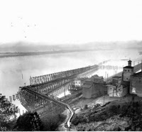
Cascades of the Columbia
 (Benjamin Gifford, 1902 via History Museum of Hood River County)

The Cascades of the Columbia was a series of rapids on the Columbia just upstream of present day Bonneville Dam (AERIAL VIEW). The Cascades are a result of the Bridge of the Gods landslide which dammed the Columbia River in the Columbia River gorge. The headwall scarp can be seen in the image above as well as the eroded toe of the slide along the bank of the river. This slide was described by native people living in the gorge and it was obvious to Lewis and Clark that the slide was a recent feature. They observed submerged trees in the river just upstream of a the narrow and rapid filled reach of the river Lewis called the Great Rapids of the Columbia.

Map of great rapids (Lewis, 1805)

The slide is a complex of huge deep-seated landslides within basalt bedrock on the north side of the Columbia River Gorge. The local Indian stories that survived place this gigantic landslide as one of the earliest recorded historic events in Washington. Giant slides like this one likely had multiple failures, but recent work suggests a mid 1400s date for the slide. Pat Pringle provides a nice summary of the work that has been done bonneville_landslide_explorations.pdf.
The landslide and the resulting rapids played a significant role in local politics and history over the centuries following the slide. The narrow river and rapids on the lower part of the Columbia River created a very important fishing location for Indians over a large area.

Net fishing on the Columbia 1918
(Leroy Child via History Museum of Hood River)

Indians would congregate here to fish and trade. It is reasonable to assume that some power plays and struggles took place to control the fishery. And the very nature of the difficult water passage would have created some sort of governance regarding moving trade goods up and down what would have been a difficult river passage. Lewis and Clark had a large enough and strong enough force as well as guns and a small cannon and valuable trade goods such that they were able to proceed without difficulty. The Hudson Bay trappers and traders learned to both physically and financially negotiate their passage through the rapids.

With arrival of Americans, the challenge of the Cascades was recognized as a problem for transport that needed to be solved. And ultimately this led to the Battle of the Cascades. Steam boats were already using the Columbia in 1856 and work had already begun to assist the passage of ships and cargo through the Cascades. The presence of Americans had disrupted the former control and opportunities the rapids had provided the regional tribes and were emblematic of what the First Nations peoples were beginning to recognize as the taking away of their lands and way of life as well as livelihoods. The Yakamas, Klickitat and Cascades Indians briefly united and attacked the American settlements in a multi day battle and siege.

A US military force from down river (Sheridan) and another from upriver (Steptoe) routed the Indians. The Yakama and Klickitat fled back to the north leaving the Cascades Indians to the harsh judgment of Colonel Wright who had nine of the Cascade Indians tried and hung for treason (it should be noted that as non US citizens the charge of treason ought not to have applied).

Post Yakama War, a series of locks was completed along the south side of the river for navigation purposes. These were later replaced by locks at Bonneville Dam when the dam was completed and the Cascades of the Columbia became submerged.

Cascades of the Columbia at low water and construction of passage around rapids
(Watkins, 1876)

Remnant of old canal looking east from highway bridge at Bridge of the Gods
         

Tuesday, January 14, 2014

Geology Trip Reference - Sterling Hill and Burlington Hill

I was out in the not so wild field and had a nice view up the Skagit Valley a bit enhanced but fog and clouds. I noted the fine lumps rising from the middle of the lower valley and would suggest if you want to know more about these lumps of rock check out Dave Tucker's field trip write up geology-field-trip-to-metamorphosed-marine-lava-and-sediment-at-burlington-hill-skagit-valley-washington/. The write up is also a good primer on the complex metamorphic assemblage that still perplexes.   


These two hills, Sterling on the left and Burlington on the right, along with the some of the mountain slopes have essentially no lower gentle slopes. The hills were former islands rising above a fjord like inlet that extended part way up the Skagit Valley. Glacial outwash from the continental ice margin that was hung up for a time to the north and the Skagit River with some contribution from the Samish River and some help from mud flows off of Glacier Peak has filled the fjord in and beyond creating a broad plain of rich flat farm land known locally as the Skagit Flats and Samish Flats.

The fields are a bit wet this time of year and deep ditches are excavated to speed drainage so that planting can start after the rain eases up and the temperature warms.  

Sunday, January 12, 2014

Rainy Sunday Post Seahawk Reading

A rainy post Seahawk victory Sunday.

/sites-that-rock/ provides a list of 105 blogs that are geology related. Worth checking out.

 http://all-geo.org/ provides a running list of various geology related posts as they are posted with just enough teaser line to help determine if it is of interest.

Non geology and non Washington State, but I enjoyed Ezra Kline discussion of tribalism psychology in comparing reactions to two policy articles both asking for the same thing but one from a "liberal" perspective and the other from a "conservative" perspective.  I can think of numerous instances of political tribalism at the State and local level, but will save that for another day.

wonkblog/wp/the-depressing-psychological-theory-that-explains-Washington

rollingstone/five-economic-reforms-millennials-should-be-fighting-for

wonkblog/five-conservative-reforms-millennials-should-be-fighting-for


Friday, January 10, 2014

Seahawk Geology

On Saturday, much of the focus of Washington State will be focused on a bit of former tide flat land near Elliot Bay. One of my ventures this week was down in south Seattle within the industrial zone a bit south of where the New Orleans Saints will be hanging out with the Seahawks. This area had some impacts from the Niscually Earthquake in the early 2000s, and for good reason - the entire area is underlain by fill over tide flats. In the early 1900s up through perhaps the 1970s, tide flats near cities was viewed a bit differently than they are today. Hence, many of our Salish Sea river deltas were greatly altered.    

1875 T Sheet

1897 geologic map

1906 topographic map showing that the filling was in full swing

The filled in tide land


1900 View of Spokane Street with West Seattle in the distance (Image from City of Seattle Archives)
Note Airport Way was not called Airport Way at that time 

View of what was to become Seattle's Industrial south side and a major port
(University of Washington Library) 
Picture by Asahel Curtis - brother of famed Indian photographer Edward Curtis


1901 Elliot Bay (University of Washington Library, Asahel Curtis)

Thursday, January 9, 2014

Wet Forest, Glacial Marine Drift and Kinglets

Right back out in the field after a bit of vacation. My first field visit was a nice mid to upper 30s and rain day in a forest underlain by glacial marine sediments - which meant lots of wet ground.


The glacial marine drift was deposited over large areas of northwest Washington during the late stages of the last glacial period approximately 13,000 years ago. The mass of glacial ice had depressed the local land surface downward in some areas hundreds of feet. When the ice began to retreat and thin, low areas in northwest Washington were flooded by sea water and the area was located below sea level with glacial ice floating on the sea surface above. As the ice melted sediment consisting mostly of clay and silt was deposited on the sea floor along with occasional sand, gravel, cobbles and boulders from the melting ice. The area has subsequently rebounded to its current elevation. Some minor reworking of the upper surface by wave action took place as the area was uplifted. The silt and clay soils have low permeability and water perches on top of the glacial marine sediments during periods of extended wet weather. 

The forest was full of small birds seeking insects and their path intersected mine. Apparently I was not viewed as a threat as they landed within feet of me, and for a second one alighted on the toe of my boot. They moved about quickly and the light was a bit dim so I did rather poorly with pictures (I could have turned on the flash, but I wanted to enjoy the little birds and feared the flash would scare them off).

I  determined this one as a golden-crowned kinglet

This one I think is female ruby-crowned kinglet
This ruby identification is mostly based on seeing one I thought was a male with its small ruby plumage and no black and white stripe. My two bird books suggest ruby-crowned should be off to the south this time of year, so my ID confidence (never real high) that it is a ruby is diminished.  

Monday, January 6, 2014

The Mountains Welcome Me Home

I've been away from Washington for the past few weeks. The mountains welcomed me home with late evening sun on the peaks after chasing the sunset across the continent.  

Glacier Peak, a strato volcano within the North Cascades

Mount Rainier

Kind of liked the name of the plane

Nice to be back in Washington but a had wonderful break with nice travel, great food and family time.  


Sunday, January 5, 2014

Maury Schwartz Has Left Us

Maury Schwartz died this past week. Maury has left a legacy in our understanding of shoreline processes in the inland waters of the Washington State both through his own research and his teaching at Western Washington University. Schwartz came to WWU in the early 1960s after a stint in the Navy during WWII, owning and running a store for ten years followed by college at Columbia University where he received his B.S, M.S. and PhD in geology.

Perhaps it was during his time in the Navy, Maury developed an interest in shoreline processes. The bulk of his research and study was focused on this subject. I frequently have come across various papers and studies he completed in Western Washington. But even more importantly, he greatly influenced and taught many of the shoreline practitioners that work today in western Washington. Our understanding of shorelines and shoreline processes has been greatly advanced through Dr. Schwartz and perhaps more importantly some his students who will and are continuing his fine work.

Excepting a required single-credit undergraduate course on science writing, I was not a student of Dr. Schwartz. My graduate work was all hard rocks, metamorphic petrology and tectonics. My studies were far removed from Dr. Schwartz's area, but being in the department as a student for that brief stint still provided opportunity to be exposed to shoreline process work as part of the broader opportunities of being at a university. Dr. Schwartz's put a lot of effort and time into broadly teaching shoreline processes beyond just the classroom and his own graduate students and some of his efforts managed to get embedded into my hard rock head.

Because Dr. Schwartz worked in a field where people interfaced with geology along shorelines, he had a deeper understanding of science and policy interaction. A sometimes difficult interface which he managed with grace and clarity. It was within that context that my fondness for Dr. Schwartz developed after I became involved in science and policy as a geologist both as consultant and for a time as an elected official. He was always very supportive of my efforts including very kind personal notes.

A bit over a year ago, I had a wonderful conversation with Maury about a particular shoreline issue and he followed up within a few days sending me a large package of papers on the subject area we discussed.

He was forever a great teacher and his enthusiasm for his science and comfort with policy implementation based on sound science has been passed on to many of us that work along the coasts of Washington State.

I'll miss seeing him and his involvement and hope I can honor his legacy.    

Friday, January 3, 2014

Blakely Bedrock Interior

I recently took advantage of the opportunity to hike across a portion the interior of Blakley Island in the eastern San Juans. I had a project site on the south part of the island and hiked to the site from where I landed my kayak on the northwest part of the island. All and all a fun field trip.

The interior is mostly forested except for the western side which has an airport and a homes. The interior is mapped as being underlain by greenstone (Whetten, 1976) and Lappen (2000) designates the interior rocks as part of the Fidalgo Ophiolite. An ophiolite is a block of ocean crust. The Fildago Ophiolite was recognized by Brown as well as Vance and is a block of ocean crust that was accreted to North America and then further displaced to its present location on Fildago island and the southwest part of the San Juans.

The section of the ophiolite outcropping in the interior of Blakely is a section of intrusive rocks that appear to be the root of a former island arc. What struck me about this rocks is how unsheared and lacking in foliation or lineations the samples I grabbed were. The north shore is mapped as tectonic zone, but as I have been discovering of late the major tectonic zones and shearing in the San Juans are surprisingly narrow.  


Glacial striations on outcrop near the western summit of the island
Although the interior is forested, soils are very thin and fresh rock samples were relatively easy to find

Mafic intrusive

Multiple intrusive injections and some mixing

Wednesday, January 1, 2014

The Forest Down Under - Kelp

I did have a nice over flight of a kelp forest late this fall. The water was clear enough that at times a bit of vertigo would hit. Don't have a lot to say about the importance of this habitat other than vague understanding that they support a lot of species. Not sure if sea otters ever lived in the San Juans for example, but there is an important association.     

Posting ability has been a bit restricted due to travel ventures - mind is mostly concentrated on non Washington landscapes.